 Filter: Categories of Wisconsin Historical Images
Filter: FORMAT_DIMENSIONS of 27 x 30 cm.
Filter: Categories of Wisconsin Historical Images
Filter: FORMAT_DIMENSIONS of 27 x 30 cm.
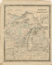
| Date: | 1860 |
|---|---|
| Description: | A hand-colored map showing the counties, major cities, ports, railroads, rivers and lakes in Wisconsin, Michigan, northern Illinois, and eastern Minnesota.... |
If you didn't find the material you searched for, our Library Reference Staff can help.
Call our reference desk at 608-264-6535 or email us at: